The River Runs Free
While the sun has nearly set on the largest dam removal project in U.S. history, it's just rising on a restoration effort to return the Klamath River to its natural state
By Thadeus Greenson [email protected] @ThadeusGreenson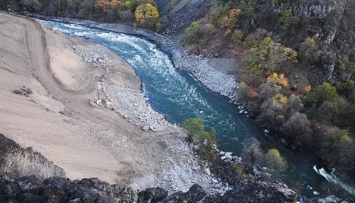
Photos by Shane Anderson/Swiftwater Films
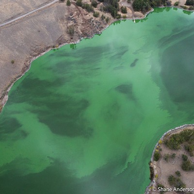
The Klamath River after the removal of Copco 2 Dam.
[

      {
        "name": "Top Stories Video Pair",
        "insertPoint": "7",
        "component": "17087298",
        "parentWrapperClass": "fdn-ads-inline-content-block",
        "requiredCountToDisplay": "1"
      }

    ]
For the first time in more than a century, the Klamath River began flowing unobstructed on Aug. 28 from the river's mouth to Keno Dam, just below Upper Klamath Lake, opening hundreds of miles of salmon habitat and bringing a generational effort to the brink of completion.
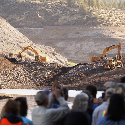
The moment an excavator broke open the last coffer dam holding the river back at what used to be Iron Gate Dam, letting the Klamath River spill into its natural path, it was met with cheers and tears by more than 100 tribal members, environmentalists and officials watching, many of whom had spent years — if not decades — working to free the river from the dams that had choked it for decades.
"It was kind of a magic moment," says Craig Tucker, a consultant with the Karuk Tribe who has worked for removal of the four dams on the lower Klamath River for more than 20 years. "You know how you have those milestone moments — like when you graduate from college and walk across the stage, and you don't really feel different? This felt different. It was like something monumental just happened, like the river is now a river, and there were a flood of emotions that went along with that. Lots of hugs."
But while the sun has nearly set on the largest dam removal effort in United States history, the work is not done and the sun is just rising on what is hoped to be one of the largest restoration efforts on record, a years-long effort to restore the lower Klamath River and its surrounding ecosystem to its natural state.
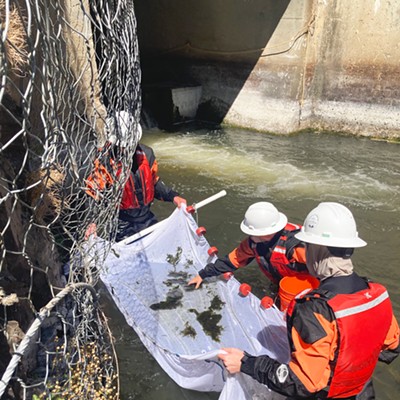
Work will continue through October to remove the last remnants of the four dams and their ancillary structures, as a team of biologists and ecologists work to manage a significant remaining threat to the adult salmon just entering the river's mouth. Meanwhile, work is underway to continue replanting and reseeding thousands of acres of land that sat for decades covered by man-made reservoirs, and to open up hundreds of miles of salmon-bearing tributaries and restore them to health.
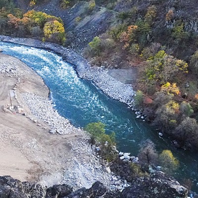
If you happen by just about any section of the lower Klamath River these days, you'll likely notice it resembles chocolate milk, turbid and muddy, filled with sediment that had been trapped for generations behind the dams.
"Removing dams is like open heart surgery, it's traumatic to the patient," Tucker says. "But you do things to mitigate the impacts."
Since the earliest stages of planning to remove the four dams — Iron Gate, Copco 1, Copco 2 and J.C. Boyle — there have been concerns about the impact of releasing the estimated 15 million cubic yards of sediment trapped behind them. Crews drew down the reservoirs behind the dams in the winter months, so naturally high-river flows would flush the sediment out to sea.
That was successful, Tucker says, but now the concern is that as the last temporary coffer dams are removed, it will release another flush of sediment — a very fine particulate resulting from years of decomposing, dead algae. The substance is anoxic, meaning it will suck oxygen from the surrounding water when released, and is too fine and liquid to scoop out with a backhoe and put in a truck. Releasing it all at once — or waiting for a rain event that would do the same — could "nuke the river," Tucker says, killing all those adult salmon just returning to spawn. As such, he says crews are currently releasing 5,000 cubic yards at a time while biologists monitor oxygen levels down river.
"We want to get all this stuff out before the adults would reach Iron Gate, but we can't evacuate it too quickly or we'll affect the oxygen levels," Tucker says, conceding it's a tricky balance that will continue until those fish reach what used to be Iron Gate Dam, which is expected to happen Sept. 20.
The good news, Tucker says, is that salmon are resilient and can deal with some turbidity, and that no matter what happens, this year will be a singular impact that will pale in comparison to the annual impacts of blocked fish passage and poor water quality the dams created.
"This is temporary," he says. "It's not going to look like this forever."
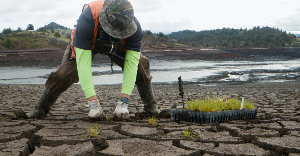
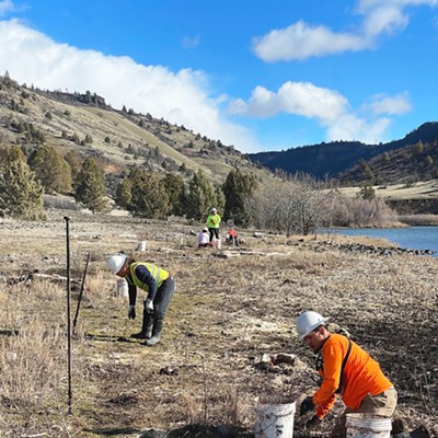
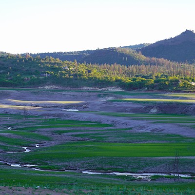
Meanwhile, work to restore the Klamath River Valley is ramping up. While seeding and planting efforts began in concert with the reservoir draw downs — with ecologists wanting to get native seed mixes on the freshly exposed reservoir floors while they were still saturated and wet — they are entering a new stage.
Dave Coffman, a geoscientist for Resource Environmental Solutions (RES), a subcontractor leading the restoration effort, says teams have spent years planning the restoration effort — amassing a bank of more than 17 billion native seeds and 300,000 tree and shrub plugs — the full reality of the job is just coming into focus.
"We spent five years planning a restoration project that we just now have access to," he says, explaining that only after the reservoirs were drawn down, allowing the river to find its path through former beds, could crews collect soil samples and test composition. "We are drinking from a fire hose when it comes to learning about our site."
Currently, he says, crews are hard at work using farming equipment to break up the dry, cracked, clay-like substance that covers the newly exposed reservoir floors, preparing them for another seeding effort. Meanwhile, he says, boulders and rocks — some taken from the earthen fill dams themselves — will be placed on the newly exposed bedrock that once supported the dams, providing important habitat that can provide respite for migrating adult salmon and protection for vulnerable fry. Then there's all those tributaries, some which have themselves been choked with sediment from decades of flowing into stagnant reservoirs. Coffman says crews will take a case-by-case approach, using equipment to excavate sediment from some, nudging others to their historic footprints, removing fish passage barriers in some and adding fallen trees to create shelter in others.
Joshua Chenoweth, a senior riparian ecologist for the Yurok Tribe, who says he's primarily responsible for reseeding the 2,000 acres of newly exposed reservoir floor, says crews will begin work in October to reseed areas that couldn't be reached when the reservoirs were drained, adding they also have 116,000 shrub and tree plugs to plant this year. Chenoweth says the seed mixes are being tweaked — with some species added and others taken out — to fit conditions of each of the former reservoirs. Another round of seeding and planting is slated for 2025.
Tucker says one thing that dawned on him when he was standing at the foot of the valley that once held Iron Gate Reservoir is that the watershed will soon have two big valleys that will soon be restored to a natural state.
"I don't know of any river valleys of this size on the West Coast that are undeveloped," he says. "We can really make this a wild, naturally productive place again."
And Tucker and others underscored that this moment would not have been possible without decades of activism from tribal nations, including the Karuk and Yurok tribes on the lower Klamath, whose culture and sustenance have been interwoven with the river for millennia.
North Coast Congressmember Jared Huffman, who joined the fight in 2012 after redistricting shifted congressional district boundaries and played an important role in the pressure campaign that ultimately brought PacifiCorp, the Berkshire Hathaway subsidiary that owned the dams, back to the negotiating table, spent some time on the river last week.
"Being part of this journey is just magic, so much so that I didn't mind at all that the river water looked like the Mississippi," he says, adding that the magnitude of the moment is palpable. "It's huge. There's no way to overstate it. This has been so long in coming, and it embodies so many hopes and dreams and long-standing grievances and injustices. It's very emotional for the tribal leaders who I work with, who have been in the trenches for decades in some cases. You can just sense a new hope and sense of satisfaction. They're practically beaming with it."
In a statement issued after the last coffer dam was breached late last month, Yurok Vice Chair Frankie Myers noted the effort was never a choice for tribal members.
"The dams that have divided the basin are now gone and the river is free," he said. "Our sacred duty to our children, our ancestors, and for ourselves, is to take care of the river, and today's events represent a fulfillment of that obligation."
But restoration will continue, and Coffman says RES' obligation remains, noting that work and monitoring efforts will continue for a minimum of five years. Ultimately, however, he says the company is bound not by time but a performance guarantee, having promised to meet certain benchmarks — like vegetative cover, trees per acre, species diversity — before the job is done.
"Nobody has ever done something like this before," he says. "We're here to see this landscape recover, here to steward it through to recovery alongside our tribal partners, the folks who have been stewarding these landscapes for millennia."
Thadeus Greenson (he/him) is the Journal's news editor. Reach him at (707) 442-1400, extension 321, or [email protected]
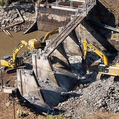
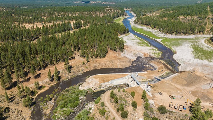
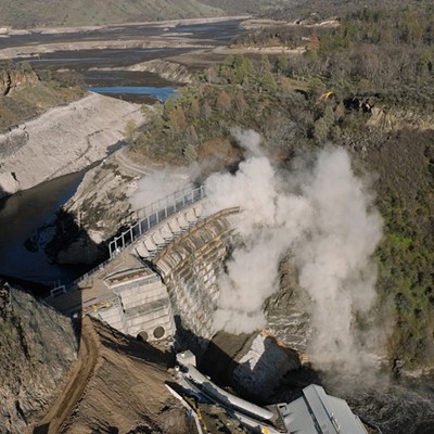
Copco 2 Dam
Build: Copco 2, a 33-foot-tall concrete dam that stretches 278 feet wide and sits between the much larger Copco 1 and Iron Gate dams, was constructed in 1925 as a diversion dam, running water from the river through a nearby powerhouse to generate electricity.
Removal: The first dam removed, Copco 2 was demolished in July of 2023 when the Klamath River Renewal Corporation brought heavy equipment into the area to prep Copco 1 for the drawing down of its reservoir in January. Contractors drilled holes 12 to 15 feet into the concrete of Copco 2, filled them with explosives and detonated them, then used hydraulic picks and other machinery to break down the rubble until it was manageable and could be hauled away.
Restoration: Due to the small footprint of Copco 2 and its proximity to Copco 1, it was not considered a primary restoration focus. Dave Coffman, a geoscientist for Resource Environmental Solutions (RES), says because Copco 2 was built in a narrow bedrock canyon with steep slopes, its infeasible to do much restoration planting around it. As such, he says the plan is to essentially let nature run its course, hoping native plants growing above it will drop seed that will catch in the canyon walls.
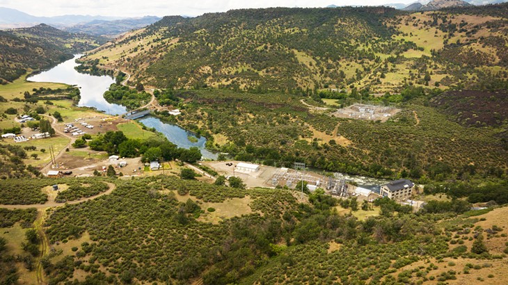
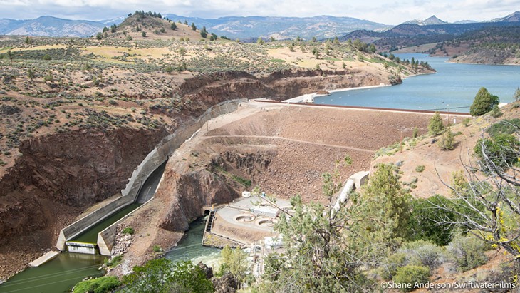
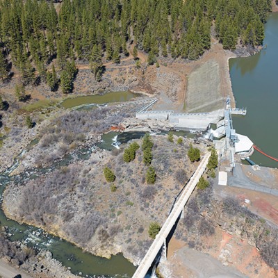
Iron Gate Dam
Build: Constructed in 1962, Iron Gate Dam is the lowest of the dams that comprise the Klamath River Hydroelectric Project, creating an artificial lake that can hold up to 58,000 acre feet of water. Standing 173 feet tall and stretching 740 feet wide, the earthen embankment dam was constructed of compacted earth under a waterproof surface.
Removal: Iron Gate Dam was removed from the top down, with excavators removing the approximately 1 million cubic yards of soil and earthen materials. Most of that earthen material was hauled away, though some was used on site to fill a spillway and a massive erosion hole it had created. Work continues to dismantle the last vestiges of the dam, as well as its ancillary structures.
Restoration: The primary restoration areas around the former Iron Gate Reservoir are the reservoir bed itself, which crews began seeding and replanting with native species as the reservoir was drawn down, and its main tributaries, including Jenny Creek, the Camp Creek Complex and Scotch Creek. Approximately 388,000 cubic yards of sediment were mechanically removed. Joshua Chenoweth, a senior riparian ecologist with the Yurok Tribe, says crews are utilizing a different seeding and planting strategy in the Iron Gate Reservoir than those upstream because it's at a lower elevation with a different climate. As such, he says they're using a customized native seed mix and planting tress like oaks and junipers, which aren't found upriver around J.C. Boyle, as well as scrub shrubs. And even within the reservoir itself, there's variation, according to Dave Coffman, a geoscientist for Resource Environmental Solutions (RES), who says crews are tailoring vegetation different for the valley's north- and south-facing slopes. "Even within the Iron Gate Reservoir itself, there's not a one-size-fits-all approach to vegetation restoration," Coffman says.
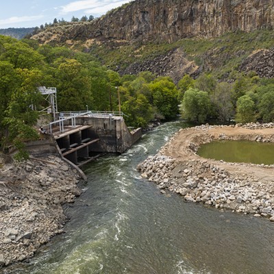
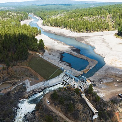
J.C. Boyle Dam
Build: Built in 1958, the John C. Boyle Dam — commonly referred to J.C. Boyle — stood 68 feet tall and 693 feet wide, creating its namesake reservoir that held 4,200 acre feet of water. The farthest upriver of the four lower Klamath dams, it was comprised of concrete and earthfill embankment.
Removal: Existing culverts were used to draw down the J.C. Boyle reservoir, after which crews demolished its spillway portion with hydraulic hammers mounted to a large excavator, progressively breaking the concrete into pieces that could be removed and hauled. Excavators and trucks then removed the earthen portion of the dam.
Restoration: The primary restoration focus around J.C. Boyle Dam is the former reservoir site, which was seeded and planted starting when drawdown began, as well as Spencer Creek and several unnamed tributaries that have reconnected with the river's main stem. An estimated 40,000 cubic yards of sediment was also mechanically removed. Because the J.C. Boyle Reservoir sees moisture before those downriver, Dave Coffman, a geoscientist for Resource Environmental Solutions (RES), says his crews have started there, using pasture remediators — a kind of farming equipment — to break up the dried clay-like reservoir beds, which Yurok Senior Riparian Ecologist Joshua Chenoweth says have cracks running 2-feet deep in some places. After the soil is broken up, crews will hand plant a custom seed mix, with Chenoweth noting, "Seed germination is all about the seed-to-soil contact," so the soil preparation work is crucial. Additionally, whereas downriver plantings will see a mix of oaks and junipers, Coffman says the J.C. Boyle area will see more ponderosa pines.
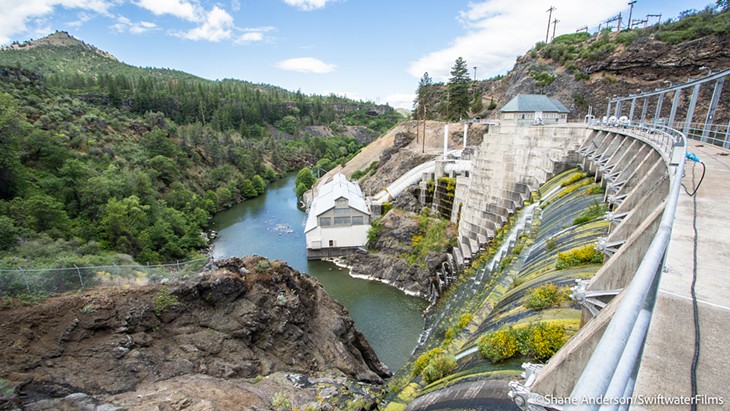
Copco 1 Dam
Build: Built in 1918, Copco 1 is a gravity dam that stands 125 feet tall and stretches 415 feet wide, creating a reservoir capacity of 46,900 acre feet in Copco Lake, which sits in Siskiyou County near the Oregon border.
Removal: Work to deconstruct Copco 1 Dam began with the installation of a "work pad" at its downstream base to allow a stable work area for heavy equipment. Crews then used a drill-and-shoot method to bore a 10-foot-wide tunnel through the dams base, meaning they repeatedly drilled into the dam, packed the hole with explosives, detonated them and excavated the rubble until they'd dug a 150-foot-long tunnel, leaving just a final plug of concrete to keep the water from escaping. In January, crews then blasted this plug, opening the tunnel to begin drawing down the reservoir. The dam was then removed much the same as Copco 2, just on a much larger scale, with crews drilling and blasting it apart, reducing it to rubble that can be hauled from the site by truck. Work continues to remove the last pieces of the dam, as well as the dam house.
Restoration: The primary focus of restoration efforts at the former site of Copco 1 have been Beaver Creek Complex, Deer Creek and the spring-fed floodplain. An estimated 346,000 cubic yards of sediment was mechanically removed from the area. While the Copco Lake area is somewhat similar to Iron Gate downriver, Dave Coffman, a geoscientist for Resource Environmental Solutions (RES), points out that they're still separated by 30 miles, noting that it's not uncommon to see snow at Copco 1 after temperatures have warmed significantly at Iron Gate. As such, while the seed mixes are generally the same, Coffman says crews are taking a customized approach to the reservoir. Coffman notes that a lava flow once blocked the Klamath River there, creating a flat, lacustrine valley that persisted for thousands of years before the river eroded it and broke through. After reservoir draw down, Coffman says it was discovered there are natural springs in the valley nobody thought would be there, saying restoration is now being tailored to include more wetland areas to accommodate "pretty significant spring flows that come from the north side of the valley."
About The Author
Thadeus Greenson
Thadeus Greenson is the news editor of the North Coast Journal.
more from the author
-
RCEA Ponders Nuclear Power
Having long eschewed nuclear energy, board to mull offer of free electricity
- Sep 12, 2024
-
Union Calls on Providence to Reverse Decision to Close Rehab Unit
- Sep 10, 2024
-
'A Segregated Campus'
Frustrations mount at Cal Poly Humboldt as ADA issues go unaddressed
- Sep 5, 2024
- More »
Latest in News


Readers also liked…
-
'To Celebrate Our Sovereignty'
Yurok Tribe to host gathering honoring 'ultimate river warrior' on the anniversary of the U.S. Supreme Court ruling that changed everything
- Jun 8, 2023
-
Pride in Full Stride
- Jun 29, 2023


