Hidden on Public Land
Enviro groups push Forest Service to release pot maps
By Grant Scott-Goforth [email protected] @GScottGoforth
[

      {
        "name": "Top Stories Video Pair",
        "insertPoint": "7",
        "component": "17087298",
        "parentWrapperClass": "fdn-ads-inline-content-block",
        "requiredCountToDisplay": "1"
      }

    ]
While there's little debate that marijuana grows on public land are hazardous to the public and the environment, there is some strife between environmental groups and the agencies that are charged with monitoring those lands.
At the heart of that dispute is just how much the U.S. Forest Service knows about "trespass grows," and whether the service and its co-agencies are doing enough with that information.
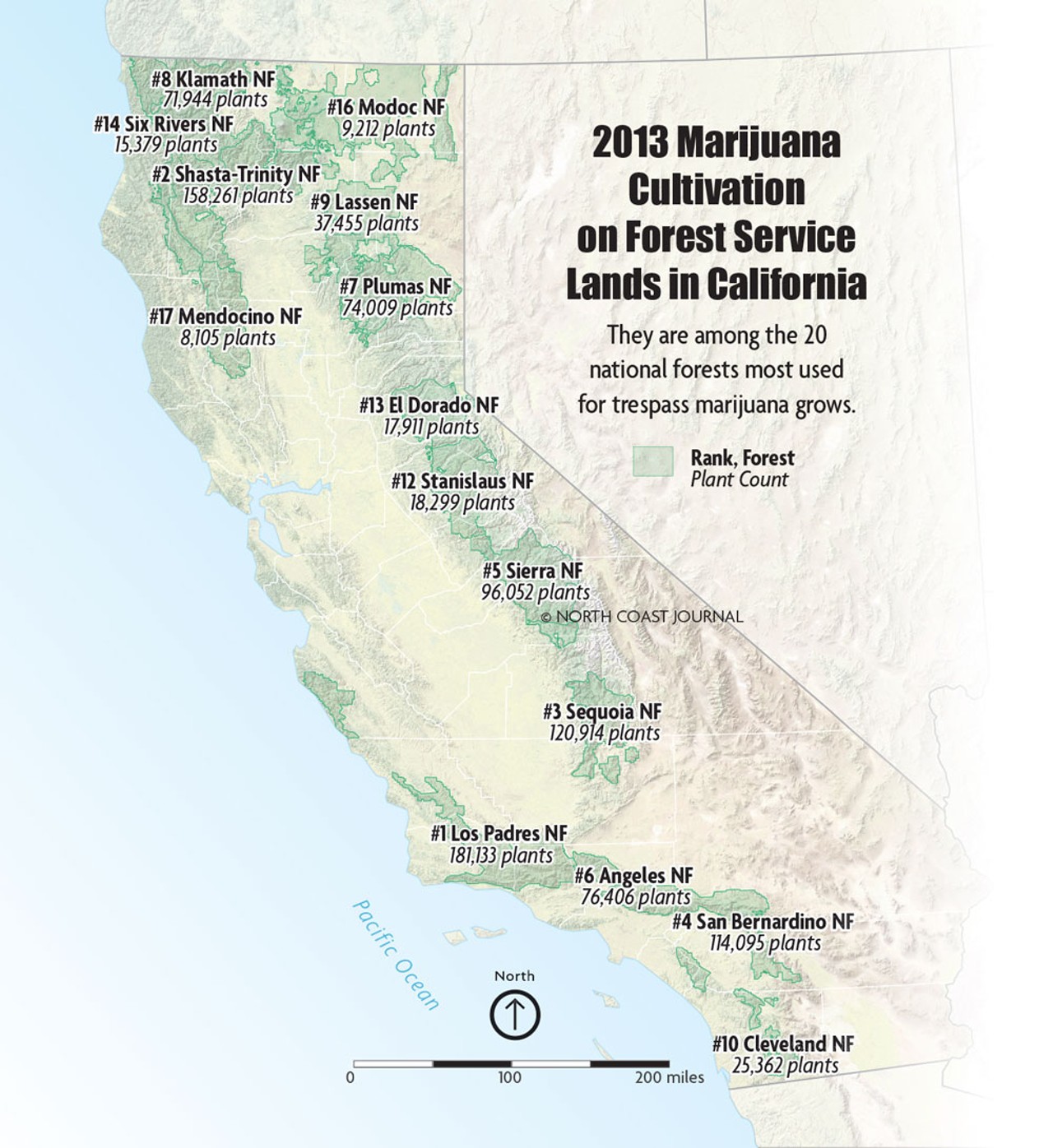
For years there have been rumors in environmentalist circles about maps. The Forest Service, they say, knows the location and size of every trespass marijuana grow on public forest land, but won't share that information. This perturbs the environmental groups that want a better grasp on the scale of the growing operations on public lands and want to hold the Forest Service accountable in several ways.
But specifics about these maps — how detailed they are, who has access to them, if they even exist — are murky.
Ryan Henson, policy director of the Redding-based California Wilderness Coalition, believes certain employees of the Forest Service have maps detailing the location and size of trespass grows. That's information his organization wants in order to get an idea of the impacts that grows could be having on wildlands. "We have tried to quantify that by getting maps of the locations of the grows," he said. "Frankly, the agencies have been reluctant to share those with us. I think they've been reluctant to share those with anyone."
Scott Greacen, director of Friends of the Eel River, echoed Henson's belief. "From extremely reliable sources, the Forest Service knows where the old grows are," he said. "We also know they have refused to share that info with environmental groups repeatedly."
The Journal asked the Forest Service for maps of trespass grows through a Freedom of Information Act request, but the request was denied. "Based on the knowledge of subject matter experts, we do not have any maps or lists that would respond to your request," the agency wrote.
There could be several plausible reasons the Forest Service didn't produce the rumored maps: They aren't official, they're part of ongoing law enforcement investigations or they don't exist. Or it could be that the maps — like the one Henson says he caught a brief glimpse of when it was offered by a Forest Service employee — are simply anecdotal information shared among staff members doing field work and then penciled onto the creased maps they carry in their back pockets.
Greacen suspects the Forest Service would simply rather the public not know how much it knows — or how little he says the agency does to prevent the grows. "The most obvious answer to me is they're embarrassed," he said. "They have failed in way too many instances to begin to address these legacy impacts."
Those impacts were the reason that the Environmental Protection Information Center initially petitioned the Forest Service for maps in 2011. In a letter to the agency, then EPIC Conservation Director Andrew Orahoske requested that the Forest Service "immediately initiate analysis of the impacts of marijuana cultivation on the Mendocino National Forest." It's the service's responsibility, EPIC argued, to "gather and evaluate new information relevant to the environmental impact of its actions" under the National Environmental Policy Act (NEPA).
EPIC was asking the service to include the impacts of marijuana growing into its forest management plan, in that case, specifically as it applied to the Mendocino National Forest.
In response, then-acting Forest Supervisor Lee D. Johnson wrote, "Cannabis cultivation on federal lands is a criminal activity, not a federal action, and therefore NEPA does not apply." Instead of looking at the broad, cumulative effect of marijuana growing on public land, Johnson continued, the Forest Service would address cleanup on a site-by-site basis.
A year later, Orahoske broadened his request to the entire Pacific Southwest region managed by the Forest Service, but again received word, in 2013, that the Forest Service felt it wasn't required to perform environmental analysis on "illegal activity undertaken by third parties and not authorized, funded or carried out by the Forest Service."
The best way to minimize impacts, the letter said, was to discourage criminal activity "through aggressive law enforcement."
That statement reflects a potential divide between the two main tenets of the Forest Service: land management and law enforcement. EPIC Executive Director Natalynne DeLapp fears there is a lack of communication between the entities, meaning biologists, foresters and other land managers may be in the dark about the scale and impacts of grows. The group hasn't pushed the Forest Service since Orahoske left EPIC, but DeLapp said it's something the organization hopes to continue once it hires a new attorney.
Despite the Forest Service's denial of maps in the FOIA request, Tommy Lanier, a former special agent for the Forest Service and National Marijuana Initiative director, said a conglomerate of law enforcement agencies has detailed information on historical and contemporary marijuana grows on public lands. "They do have maps," he said. "We've got great technology nowadays. It goes into an intelligence database."
As the director of the National Marijuana Initiative, Lanier's job was to bring together a group of public land and law enforcement agencies that includes the Bureau of Land Management, the Forest Service, the U.S. Department of Justice and the National Guard. About 10 years ago, when the groups started to notice the environmental degradation from trespass grows, the initiative began to include academia, seeking scientific and university research that would analyze those impacts.
"Those public land agencies ... they've got every grow pinpointed on a map," Lanier said, but it's not that they're hiding them from the public. It's that the law enforcement side has gotten more sophisticated in its approach, seeking not just to bust grows, but to trace the distribution routes of the marijuana. This can take years, he said, and solid prosecution is key to keeping grows from proliferating. Just handing out details of where grows are would "jeopardize the larger cases they have going on," he said.
The maps also help the National Guard seek out old grow sites to clean up, Lanier said. "It's about $25,000 to $35,000 to set up a good grow. If [growers] can use that grow over and over, they will. One thing that's a great market disruption is taking everything out. Do they want to invest that money and time knowing that we know ... there was a grow there?"
Another disruption, environmental groups claim, would be the removal of old forest roads, which they believe make it easier for growers to set up marijuana gardens in the wilderness.
Greacen said old roads facilitate all kinds of illegal activity on public lands. "When you keep unnecessary, failing roads open deep into wild country, logging almost inevitably follows," he said. But because of pressure from advocates for road access, Greacen said, little is done to deconstruct those roads. "From our perspective it's been clear the Forest Service wants to keep open many more miles of roads than it has money to maintain, or should maintain."
Henson said roads — even in protected wilderness areas — are important resources for the public who want to recreate. "I absolutely believe in road access," he said. But geographical analysis of grow sites could help show if, and how, roads are used by trespass growers.
"The one time someone did flash me a map it was very clear that the grow sites were clustered around the road network," Henson said. Though, he added, that could be survey bias — meaning perhaps the Forest Service is simply more likely to discover the grows located closer to roads. Still, he said, it's a problem, particularly in the Shasta-Trinity National Forest, where he said 5,000 miles of old, unused roads were never effectively closed. "Those roads to nowhere really are an invitation to illegal grows."
The same happens in Mendocino County, Henson said. "Blands Cove Road near Covelo — it seems to lead every year to growing in exactly the same place. I've long urged the Forest Service to more closely monitor the road or just close the road because it's just an attractive nuisance.
"Whiskeytown National Recreation Area [maintained by the National Park Service] closed all of their roads north of [State Route] 299 because they felt that would significantly cut down on illegal pot grow. And it did. The Forest Service needs to look at that just like the Park Service did."
Lanier said he doesn't see public road access as a double-edged sword, "I look at it as the bad guys taking advantage of the remoteness. ... We're going to get people who take advantage like that. Whether it's illegal mining practices or to grow marijuana."
Public land agencies have come a long way in their own education and informing the public since decades ago, Lanier said, when the first concerns about trespass growing arose. "Nobody ever wanted to actually come out and say, 'We should really tell the public there are a lot of dope growers on public lands with guns.' It was a hard sell."
But they're coming around. "It's upon us to inform and educate everybody," Lanier said, and "we need to continue to encourage people to use public lands."
Knowing trespass grows are a problem in his district, North Coast Congressman Jared Huffman introduced the Protecting Lands Against Narcotics Trafficking (PLANT) Act last summer, intending to establish new, harsher penalties for people caught causing environmental damage while growing marijuana on state or federal lands. At a recent meeting with local law enforcement, Huffman said the U.S. Sentencing Committee has taken up the charge on its own and new sentencing guidelines should be in place by September.
"I hope this is a nice, new tool for law enforcement to go after these trespass growers," he said, adding that the stiffer penalties could incentivize prosecutors to take on these types of cases while dissuading growers from engaging in the practice. However, Huffman said he realizes increased penalties will only go so far in addressing the pervasive problem.
"I don't pretend these new sentencing guidelines will be the silver bullet," he said. National decriminalization or legalization of marijuana, Huffman continued, is the only thing that will halt trespass grows.
Until then, most believe grows are likely to continue to pock public lands for the foreseeable future. For his part, Greacen said trespass grows are a matter of national security, and urges the Forest Service to release all the information it has about grows to the public. Until that information is released, he said, important questions will remain unanswered.
"What areas critical to wildlife and to fish have been impacted?" he asked "Collectively, how has the agency been mitigating those impacts — or have they?"
Comments (3)
Showing 1-3 of 3
About The Author

Grant Scott-Goforth
Grant Scott-Goforth was an assistant editor and staff writer for The Journal from 2013 to 2017.
more from the author
-
Flamin' Hot's Stale Corporate Propaganda
- Jun 15, 2023
-
Hell is Visiting Other People
- Sep 22, 2022
-
The Bear Roars
- Aug 18, 2022
- More »
Latest in News


Readers also liked…
-
Through Mark Larson's Lens
A local photographer's favorite images of 2022 in Humboldt
- Jan 5, 2023
-
'To Celebrate Our Sovereignty'
Yurok Tribe to host gathering honoring 'ultimate river warrior' on the anniversary of the U.S. Supreme Court ruling that changed everything
- Jun 8, 2023


