Tuesday, December 27, 2022
Community / Emergency / Government / Outdoors
UPDATE: Mad River Expected to Hit Monitor Stage, Record Rain as Storm Lashes Humboldt, High Surf Hits the Coast
Posted By Kimberly Wear @kimberly_wear on Tue, Dec 27, 2022 at 10:38 AM

UPDATE:
The Mad River is now expected to hit Monitor Stage near Arcata this afternoon or evening as well as again on Friday, continuing into the weekend, according to NWS.
“At 15 ft the river can flood Mad River Road near Tyee City,” NWS states. “This can be treacherous as the road runs right along the river. Turn around, don't drown.”
PREVIOUS:
The Mad River is now expected to hit Monitor Stage near Arcata this afternoon or evening as well as again on Friday, continuing into the weekend, according to NWS.
“At 15 ft the river can flood Mad River Road near Tyee City,” NWS states. “This can be treacherous as the road runs right along the river. Turn around, don't drown.”

PREVIOUS:
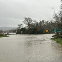
High winds and lashing rain hit Humboldt County overnight, leaving a swath of residents across the region while the National Weather Service reports that a record amount of rain fell at Woodley Island for the date of Dec. 26.
According to NWS, 1.91 inches was recorded, breaking the previous record of 1.68 inches set in 1931.
For more area-specific forecasts, visit https://www.weather.gov/eka/ and find the PG&E outage page here.
Just around 9 a.m, the Smith River at Dr. Fine Bridge was approaching Monitor Stage. “Additional small rises are possible but the river is not expected to reach flood stage,” a NWS post states.
The Eel River at Fernbridge was observed to be rising this morning as well, with the possibility of hitting just above Monitor Stage tomorrow, according to the NWS Hydrologic Prediction Service.
Caltrans QuickMap shows multiple traffic hazards across the region, including emergency work on the southbound U.S. Highway 101 offramp at South G Street, a pole down on Briceland Thorn Road, a tree down on Wilder Road at Mattole Road,
Meanwhile, high surf is set to pound the coast this morning, with 25-foot swells and breakers in the 22- to 26-foot range in the surf zone, creating dangerous conditions for beach-goers and mariners.
The NWS is asking residents to send in any flooding or wind reports, either by filling out a form at https://inws.ncep.noaa.gov/report or post it on the Eureka office's Facebook page.
Speaking of...

Readers also liked…
About The Author
Kimberly Wear
Bio:
Kimberly Wear is the assistant editor of the North Coast Journal.
Kimberly Wear is the assistant editor of the North Coast Journal.
more from the author
-
Huffman Joins Colleagues in Calling for Biden to ‘Pass the Torch’
- Jul 19, 2024
-
SECOND UPDATE: Victim of Fatal Shooting Identified
- Jul 17, 2024
-
Eureka Man Killed in SoHum Crash
- Jul 1, 2024
- More »


