Monday, September 13, 2021
Knob Fire 100 Percent Contained as Hopkins Fire Takes a Toll in Mendocino (with Video)
Posted By Kimberly Wear @kimberly_wear on Mon, Sep 13, 2021 at 10:24 AM
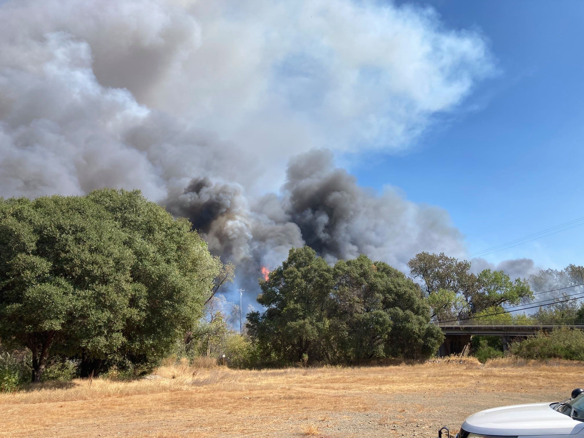
The Knob Fire, which broke out near Willow Creek, is officially 100 percent contained with all evacuation orders and warnings lifted over the weekend as others in the region grow and a new one started in Calpella in Mendocino County, threatening some 200 structures with others reported to have been destroyed.
With fires raging across the region and resources already stretched very thin, the U.S. Forest Service has temporarily closed nine National Forests, including Klamath, Mendocino, Shasta-Trinity and Six Rivers.
Here's a brief look at each of the first burning near Humboldt and what you need to know.
The Fires
The Hopkins Fire, 257 acres, 20 percent contained
An evacuation center has been set up at theMendocino County Office of Education, 2240 Old River Road, in Ukiah and a large animal shelter site at the Redwood Empire Fair Grounds, 1055 State St. and the Ukiah Mendocino County Animal Shelter on Plant Road in Ukiah.
For the latest information, click here.
The Monument Fire, 212,517 acres, 41 percent contained
Located a half mile west of Big Bar along State Route 299 east of Willow Creek, the Monument Fire was sparked by lightning on July 30.
State Route 299 has reopened but only during the day and with pilot cars leading traffic in both directions from Burnt Ranch to Helena at designated times every hour and a half starting at 7 a.m. until 7 p.m. The road will be closed from 7 a.m. to 7 p.m. for everyone except local residents with proof of address and emergency traffic. There is also one-way controlled traffic at various locations from 0.7 miles east of the State Route 96 junction at Panther Road in Humbodt County to 0.9 miles east of the Humboldt/Trinity countyline.
For information on evacuation orders and warnings, evacutation sites and animal shelters, visit the Trinity County Sheriff's Office Facebook page here.
For more information, check the incident website here and a map of the fire's footprint here.
River Complex 2021, 185,862 acres, 30 percent contained
Located in the Salmon/Scott River Ranger District of the Klamath National Forest, the complex consists of multiple lightning fires sparked in dry timber and brush on July 30. The full complex stretches more than 185,000 acres and originally included 31 fires, three of which remain: the Cronan, which is under patrol status, and the Summer and Haypress fires, which have combined.
Over the last week, the complex has grown by 50,000 acres.
For specific information regarding evacuations please visit https://www.co.siskiyou.ca.us/emergencyservices or https:///www.trinitycounty.org/OES.
Find more information here and a map of the fires' footprints here.
The McCash Fire: 75,895 acres, 11 percent containment
Sparked by lightning on July 31, the McCash Fire is burning near Somes Bar in the Marble Mountain Wilderness in Siskiyou County in an area of timber growth with an understory of tall grass and brush.
Over the last week, the fire has grown by some 20,000 acres and lost ground on containment, going from 15 percent on Sept. 7 to 11 percent as of this morning.
"There is a Red Flag Warning for the area from 1 p.m. to 11 p.m. due to strong winds from the north/northeast, which are expected to heighten fire behavior," this morning's update states. "Most of the fire activity has been south of Lick Creek area and that is expected to continue. Helicopters have been dropping water to slow the fire spread as it approaches Chicken Ladder Road. Dozer line is complete along Titus Ridge and firefighters have completed handline along the ridge above Malone Creek down to Elk Creek."
For evacuation orders and warnings in place for areas of Siskiyou County, visit the county's website for up-to-date information here or the sheriff's office Facebook page here.
The fire threatens significant cultural sites for the Karuk Tribe, as well as some structures on private lands. The current estimated containment date is Oct. 31. Find more information here.
Travel
State Route 299: Reopened during the day with pilot cars leading traffic in both directions from Burnt Ranch to Helena at designated times every hour and a half from 7 a.m. to 7 p.m. The road will be closed from 7 p.m. to 7 a.m. to everyone except local residents with proof of address.
State Route 36: Open.
For the most up to date road information, visit CalTrans' road information site here.
Air Quality
For the latest North Coast Unified Air Quality Management District information, click here.
"Moderate" — Sensitive individuals should limit prolonged or heavy exertion "Unhealthy for Sensitive Groups" — Sensitive groups should reduce prolonged or heavy outdoor exertion
"Unhealthy" — Sensitive groups should avoid all prolonged or heavy outdoor exertion
"Very Unhealthy" — Everyone should avoid prolonged or heavy exertion
"Hazardous" — Everyone should avoid any outdoor activity
For the latest air quality information, click here and here.
With fires raging across the region and resources already stretched very thin, the U.S. Forest Service has temporarily closed nine National Forests, including Klamath, Mendocino, Shasta-Trinity and Six Rivers.
Here's a brief look at each of the first burning near Humboldt and what you need to know.
The Fires
The Hopkins Fire, 257 acres, 20 percent contained
Located at Hopkins and North State streets in Calpella in Mendocino County, the Hopkins Fire started Sept. 12 by undetermined causes. A Damage Inspection Team has been requested, according to the Mendocino County Sheriff's Office.
"Overnight, firefighters made good progress with the assistance of lower temperatures and higher humidity," this morning's update states. "Firefighters on the ground as well as aircraft will continue to actively work to suppress the fire. A damage assessment team has been requested to survey the fire area to determine how many structures have been damaged or destroyed. We ask that the public heed all evacuation orders and warnings."
Evacuation orders have been issued for the Calpella area in the vicinity of 2RWV07, 2RWV09, 2RWV10, 2UKV26, 2UKV08, 2UKV13. Mandatory evacuation for the area of Road 144 to 50000 block of eastside of Calpella.
An evacuation center has been set up at theMendocino County Office of Education, 2240 Old River Road, in Ukiah and a large animal shelter site at the Redwood Empire Fair Grounds, 1055 State St. and the Ukiah Mendocino County Animal Shelter on Plant Road in Ukiah.
For the latest information, click here.
The Monument Fire, 212,517 acres, 41 percent contained
Located a half mile west of Big Bar along State Route 299 east of Willow Creek, the Monument Fire was sparked by lightning on July 30.
State Route 299 has reopened but only during the day and with pilot cars leading traffic in both directions from Burnt Ranch to Helena at designated times every hour and a half starting at 7 a.m. until 7 p.m. The road will be closed from 7 a.m. to 7 p.m. for everyone except local residents with proof of address and emergency traffic. There is also one-way controlled traffic at various locations from 0.7 miles east of the State Route 96 junction at Panther Road in Humbodt County to 0.9 miles east of the Humboldt/Trinity countyline.
While several days of "stabilized weather conditions" gave crews a chance to make progress on the active portions of the fire west of Hayfork, in the New River drainage, and along the East Fork North Fork Trinity River, the forecast does call for "warming and drying trend in the next several days," which could increase fire activity, according to an update from Sunday.
The fire grew by 30,000 acres over the last week while remaining at about the same level of containment.For information on evacuation orders and warnings, evacutation sites and animal shelters, visit the Trinity County Sheriff's Office Facebook page here.
For more information, check the incident website here and a map of the fire's footprint here.
River Complex 2021, 185,862 acres, 30 percent contained
Located in the Salmon/Scott River Ranger District of the Klamath National Forest, the complex consists of multiple lightning fires sparked in dry timber and brush on July 30. The full complex stretches more than 185,000 acres and originally included 31 fires, three of which remain: the Cronan, which is under patrol status, and the Summer and Haypress fires, which have combined.
Over the last week, the complex has grown by 50,000 acres.
For specific information regarding evacuations please visit https://www.co.siskiyou.ca.us/emergencyservices or https:///www.trinitycounty.org/OES.
Find more information here and a map of the fires' footprints here.
The McCash Fire: 75,895 acres, 11 percent containment
Sparked by lightning on July 31, the McCash Fire is burning near Somes Bar in the Marble Mountain Wilderness in Siskiyou County in an area of timber growth with an understory of tall grass and brush.
Over the last week, the fire has grown by some 20,000 acres and lost ground on containment, going from 15 percent on Sept. 7 to 11 percent as of this morning.
"There is a Red Flag Warning for the area from 1 p.m. to 11 p.m. due to strong winds from the north/northeast, which are expected to heighten fire behavior," this morning's update states. "Most of the fire activity has been south of Lick Creek area and that is expected to continue. Helicopters have been dropping water to slow the fire spread as it approaches Chicken Ladder Road. Dozer line is complete along Titus Ridge and firefighters have completed handline along the ridge above Malone Creek down to Elk Creek."
For evacuation orders and warnings in place for areas of Siskiyou County, visit the county's website for up-to-date information here or the sheriff's office Facebook page here.
The fire threatens significant cultural sites for the Karuk Tribe, as well as some structures on private lands. The current estimated containment date is Oct. 31. Find more information here.
Travel
State Route 299: Reopened during the day with pilot cars leading traffic in both directions from Burnt Ranch to Helena at designated times every hour and a half from 7 a.m. to 7 p.m. The road will be closed from 7 p.m. to 7 a.m. to everyone except local residents with proof of address.
There is also one-way controlled traffic at various locations from 0.7 miles east of the State Route 96 junction at Panther Road in Humbodt County to 0.9 miles east of the Humboldt/Trinity countyline.
State Route 36: Open.
For the most up to date road information, visit CalTrans' road information site here.
Air Quality
Humboldt County:
• Eureka (including Scotia to Trinidad) – Good to Moderate; areas of haze; periods of USG at higher elevations
• Orleans – Moderate; afternoon smoke impacts; evening clearing
• Weitchpec – Moderate, afternoon smoke impacts; evening clearing
• Hoopa Valley – Moderate to USG; afternoon smoke impacts; evening clearing
• Willow Creek – Moderate; afternoon smoke impacts; evening clearing
• Garberville & Redway – Good in the morning with Moderate to USG in afternoon
For the latest North Coast Unified Air Quality Management District information, click here.
"Moderate" — Sensitive individuals should limit prolonged or heavy exertion "Unhealthy for Sensitive Groups" — Sensitive groups should reduce prolonged or heavy outdoor exertion
"Unhealthy" — Sensitive groups should avoid all prolonged or heavy outdoor exertion
"Very Unhealthy" — Everyone should avoid prolonged or heavy exertion
"Hazardous" — Everyone should avoid any outdoor activity
For the latest air quality information, click here and here.
Speaking of...
-
Local Commercial Dungeness Crab Season to Open in January
Dec 20, 2023 -
Huffman, Citing Rio Dell, Asks FEMA for more ‘Flexible, Equitable’ Access to Disaster Aid
Sep 25, 2023 -
CA Officials Respond to Tropical Storm Hilary, Ojai quake and Wildfires with the Possibility of More Lightning in the Forecast
Aug 21, 2023 - More »
Readers also liked…
About The Author
Kimberly Wear
Bio:
Kimberly Wear is the assistant editor of the North Coast Journal.
Kimberly Wear is the assistant editor of the North Coast Journal.
more from the author
-
Eureka Man Killed in SoHum Crash
- Jul 1, 2024
-
Caltrans Selects Tunnel Option for Last Chance Grade
- Jun 18, 2024
-
Kyle Steven Wear: 1970 —2024
- Jun 16, 2024
- More »


