Monday, October 5, 2020
Updates on the Red Salmon, Slater-Devil Fires
Posted By Kimberly Wear @kimberly_wear on Mon, Oct 5, 2020 at 5:33 PM

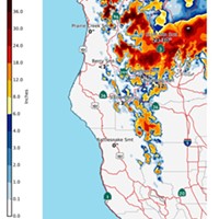
Red Salmon Complex — 133,763 acres and 34 percent containment
Smoky conditions are continuing to impact communities around the Red Salmon Complex. The fire is continuing as planned toward Knownothing Creek as it backs along the South Fork of the Salmon River to Cecilville Road, according to today’s update.
Structure protection in the area is continuing and crews are removing hazardous such as damaged trees. Firefighters are working to widen containment lines from the wilderness of the Cecilville area to St. Clair Creek and Barefoot Ridge.
Firefighters are working to protect structures in the Godfrey, Black Bear and Blue Ridge areas. The fire has been holding well the southwest area, continuing to line up with Horse Linto Creek as additional fire line is being constructed along Lone Pine Ridge.

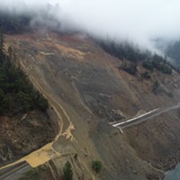
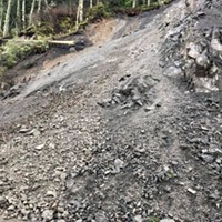
Slater Fire – 155,096 acres and 62 percent containment
Crews are working to prevent the westward movement of the fire as it is being directed toward the containment line in the Knopki Creek area east of Highway 199, according to today’s update.
Crews are working to prevent the westward movement of the fire as it is being directed toward the containment line in the Knopki Creek area east of Highway 199, according to today’s update.
Residents in the area of the fire, which straddles the California-Oregon border and continues down to Happy Camp, can expect to see smoke from firing operations as well as vegetation and other fuels in the fire’s interior, which are expected to continue burning and smoldering until the first major rain of the season.
Meanwhile, crews are working to remove hazardous trees on both sides of the Grayback Road between Takilma and Happy Camp to protect firefighters, residents and those working to restore power to Happy Camp.
The north, northwest and southern flank of the fires have crew working on mopping up, extending containment lines in some areas and putting out hot spots in others.
Read more about the fires here.
Devil Fire - 8,650 acres and 27 percent containment
There is an active patch on the fire’s east side but containment lines are holding as mop up and patrols continue on the northern and southern sections.
Evacuations information:
Josephine County information: 541-474-5305 or www.facebook.com/josephinecountyEM, www.co.josephine.or.us/fire, or www.rvem.org
Siskiyou County information: (530) 841-2900 or www.facebook.com/SiskiyouCountySheriff/
Del Norte County information: (707) 464-7213 or www.facebook.com/DelNorteOfficeOfEmergencyServices and www.preparedelnorte.com/
The Bureau of Land Management Medford District has public lands closures in effect near the Slater Fire and South Obenchain Fire.
Closure area maps are available at: www.blm.gov/programs/public-safety-and-fire/fire-and-aviation/regional-info/oregon-washington/fire-restrictions.
Speaking of...
Readers also liked…
About The Author
Kimberly Wear
Bio:
Kimberly Wear is the assistant editor of the North Coast Journal.
Kimberly Wear is the assistant editor of the North Coast Journal.
more from the author
-
Fortuna Resident Killed in 299 Crash
- Sep 23, 2024
-
Officials Urge Caution After 2 Dogs Die Following Swim By Fernbridge
- Sep 6, 2024
-
ECS Board Directs Staff Back to CHP on Jacobs Sale
- Sep 5, 2024
- More »


